Weatherman warns of heavy rains, as Cyclone Chenge approaches Kenyan coastline
The weatherman said the system could bring rough seas and strong winds exceeding 25 knots along southern coastal areas.
The Kenya Meteorological Department has warned of heavy rainfall and gusty winds, particularly along the coastal counties, as the weakening low-pressure system Chenge moves closer to the East African coast.
In an update on Sunday, the weatherman said the system could bring rough seas and strong winds exceeding 25 knots along southern coastal areas.
More To Read
- Nairobi County issues public health alert as heavy rains trigger flooding, contamination fears
- Met Department issues heavy rainfall warning for Western, Rift Valley regions
- Nairobi among several counties to experience showers and thunderstorms this week - Weatherman
- Kenya Met warns of reduced rainfall but showers to continue in parts of the country
- Kenya to experience rains, thunderstorms, strong winds this week
- Kenya Met forecasts delayed, suppressed short rains amid dry spells
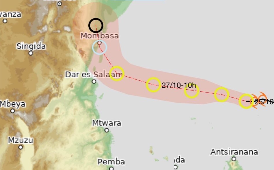
The department noted that Cyclone Chenge, now classified as a residual depression, is located near 8.2°S / 50.2°E, about 500 kilometres north of Madagascar. The system is moving west-northwest at 11 km/h with maximum sustained winds of 55 km/h, gusting up to 75 km/h, and a central pressure of 1000 hPa.
“KMD continues to monitor tropical weather systems over the southwest Indian Ocean. A low-pressure system, Chenge (Residual Depression), is currently located near 8.2°S / 50.2°E, about 500 km north of Madagascar, moving west at 11 km/h,” the weatherman said.
The forecast indicates that Chenge will drift across the northern Mozambique Channel, gradually losing strength, and is expected to dissipate near the coasts of Tanzania and southern Kenya by Tuesday, October 28, 2025.
Although no cyclone alert has been issued for Kenya, KMD cautioned that the weakening system could still cause heavy rainfall and strong winds exceeding 25 knots along coastal counties such as Kwale, Mombasa and Lamu on Monday and Tuesday.
Fishermen and marine operators have been urged to exercise caution due to possible rough seas and gusty winds.
Meanwhile, the department said Mayotte will not be under cyclone alert but could experience swells of around two metres between Sunday and Monday. The Astove and Aldabra archipelagos in Seychelles are expected to see heavy rain and dangerous sea conditions through the weekend, while northern Madagascar will remain mostly clear, with only localised rough seas possible.
KMD confirmed that no other tropical systems are expected to develop in the southwest Indian Ocean over the next five days.
“The department will continue to closely monitor the situation and issue updates as necessary,” it said, urging the public to follow official weather updates through verified channels.
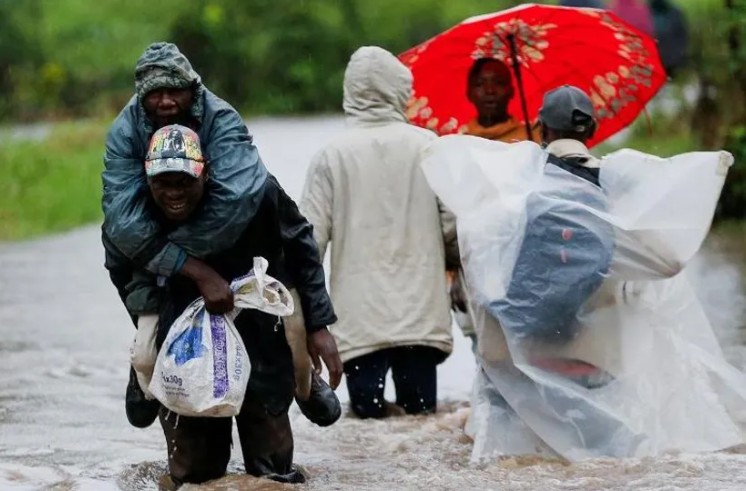
The warning comes a few days after the department issued a heavy rainfall advisory, warning of potential floods and landslides in parts of the country. The advisory warned that rainfall could exceed 30mm within 24 hours and spread to the Highlands east of the Rift Valley, including Nairobi and surrounding areas.
“Rainfall currently affecting parts of the Lake Victoria Basin, the Rift Valley, and the Highlands west of the Rift Valley is expected to intensify to more than 30mm in 24 hours and spread to the Highlands east of the Rift Valley, including Nairobi and parts of the southeastern lowlands,” reads the statement.
The department said the heavy rainfall is expected to continue and extend to parts of the northeast starting Thursday, October 30, marking the onset of the Short Rains Season (OND) 2025 in many areas, except for some southeastern lowlands and coastal regions.
Residents in affected counties, including Kisumu, Homa Bay, Siaya, Migori, Busia, Kisii, Nyamira, Nandi, Kericho, Bomet, Kakamega, Vihiga, Bungoma, Narok, Baringo, Nakuru, Trans-Nzoia, Uasin-Gishu, Elgeyo-Marakwet, West Pokot, Turkana, Isiolo, Samburu, Marsabit, Mandera, Wajir, Nyandarua, Laikipia, Nyeri, Kirinyaga, Murang’a, Kiambu, Meru, Embu, Tharaka-Nithi, Nairobi, and parts of Kajiado, Machakos, and Makueni, have been urged to stay alert for potential floods.
Flood waters could appear in places where rainfall was minimal, especially downstream. Residents have been advised to avoid driving or walking in moving water, open fields or sheltering under trees or near grilled windows to minimise exposure to lightning. Those living in landslide-prone areas, especially on the slopes of Aberdare Ranges, Mt. Kenya and other steep areas in western Kenya, were urged to be on high alert.
In Tanzania, the Meteorological Authority (TMA) said Cyclone Chenge remains over the southwest Indian Ocean, moving west while gradually losing strength. As of October 25, 2025, the system was about 1,280 km east of Mafia Island.
TMA forecasts that Chenge will continue moving west across the southwest Indian Ocean, weakening as it approaches the East African coast. It noted that the cyclone could cause slightly stronger winds and high sea waves between October 26 and 28 along the Tanzanian coast, with a low chance of heavy rainfall over Zanzibar and Pemba islands, as well as the regions of Morogoro, Pwani, Dar es Salaam and Tanga.
“The TMA continues to monitor Cyclone Chenge and its impacts on national weather systems and will provide updates as necessary,” the authority said, urging marine operators and the public to follow official weather forecasts and seek guidance from sector experts.
Top Stories Today